Share Ridge Street Active Transport Upgrade - Stage 2 on FacebookShare Ridge Street Active Transport Upgrade - Stage 2 on TwitterShare Ridge Street Active Transport Upgrade - Stage 2 on LinkedinEmail Ridge Street Active Transport Upgrade - Stage 2 link
Consultation has concluded
STAGE 2 - FEEDBACK CLOSED 17 NOVEMBER 2019
PROJECT BACKGROUND
The North SydneyCommunity Strategic Plan 2018–2028 identifies improved walking and cycling connections as a key priority for the community, with feedback consistently indicating that people will walk and cycle more when safe and convenient routes are available.
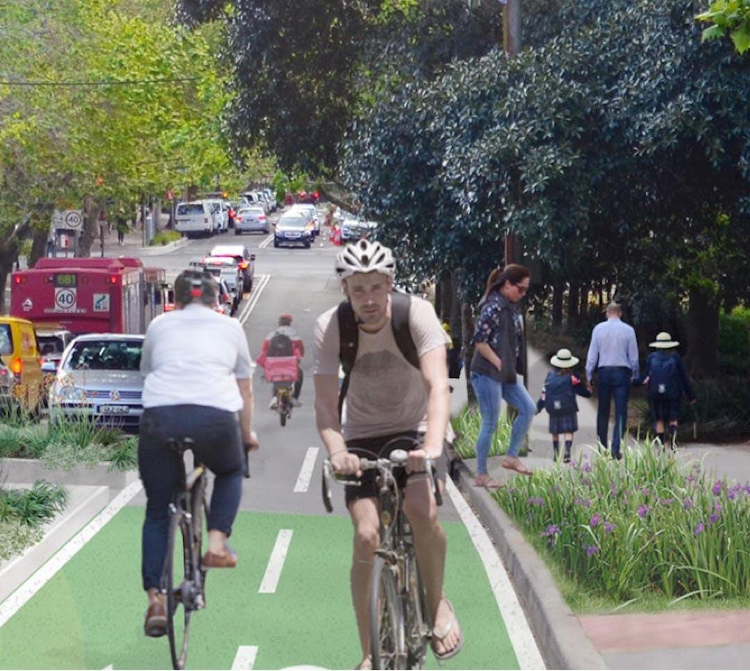
The Ridge Street Active Transport Upgrade Plan provides improved walking and cycling facilities along with other benefits including additional street trees, landscaping, high-quality paving and more on-street parking.
Stage 2 works have been designed to deliver part of the footpath network proposed in the St Leonards Park Masterplan and provide an alternative cycling option to the internal path across the park. This project is fully funded by Roads and Maritime Services 2019/2020 Active Transport Priority Cycleways Project. The cycle path will complement the NSW Government’s regional cycling network and will be part of the Principle Bike Network which is scheduled to be completed by 2026.
STAGE 2 - PROJECT DETAILS
Key features of proposed Stage 2 works (Miller Street to Warringah Freeway overpass) include:
Expanded and improved pedestrian access along the southern edge of St Leonards Park including a new footpath and large areas of landscaped garden beds. Sections of the new footpath with be elevated to protect the roots of significant Fig trees within the park.
A bi-directional cycle path along the north side of Ridge Street separated from road and footpath areas. This type of path has been proven to make cycling accessible to a broader age and cycling ability range.
Retention of car parking spaces on both sides of Ridge Street and the creation of three (3) additional parking spaces on the north side of Ridge Street.
Road safety improvements via reduced lane widths, encouraging slower vehicle speeds, and reduced crossing distances forpeople walking.
Completing missing sections of the footpath network such as missing pram ramps over Ridge Street near to the intersection with Walker Street.
The design/layout proposed is based on similar active transport/streetscape upgrade projects implemented successfully in other parts of North Sydney, Sydney and internationally.
While the works propose to reduce the lane widths and are expected to slow traffic on Ridge Street, as per Stage1, the widths will remain between 2.7. and 3m, which is within the acceptable, relevant guidelines and standards for lane width. The expected reduction in vehicle speeds will further provide a pedestrian friendly local road setting in Ridge Street. The proposal allows for the number of on-street carparking spaces to be increased by three (3) spaces.
View the concept plan to see key features of the proposed design (in the Document Library).
For further information contact Lindsay Menday, Council's Engineering and Property Services Division on 9936 8100.
STAGE 2 - FEEDBACK CLOSED 17 NOVEMBER 2019
PROJECT BACKGROUND
The North SydneyCommunity Strategic Plan 2018–2028 identifies improved walking and cycling connections as a key priority for the community, with feedback consistently indicating that people will walk and cycle more when safe and convenient routes are available.
The Ridge Street Active Transport Upgrade Plan provides improved walking and cycling facilities along with other benefits including additional street trees, landscaping, high-quality paving and more on-street parking.
Stage 2 works have been designed to deliver part of the footpath network proposed in the St Leonards Park Masterplan and provide an alternative cycling option to the internal path across the park. This project is fully funded by Roads and Maritime Services 2019/2020 Active Transport Priority Cycleways Project. The cycle path will complement the NSW Government’s regional cycling network and will be part of the Principle Bike Network which is scheduled to be completed by 2026.
STAGE 2 - PROJECT DETAILS
Key features of proposed Stage 2 works (Miller Street to Warringah Freeway overpass) include:
Expanded and improved pedestrian access along the southern edge of St Leonards Park including a new footpath and large areas of landscaped garden beds. Sections of the new footpath with be elevated to protect the roots of significant Fig trees within the park.
A bi-directional cycle path along the north side of Ridge Street separated from road and footpath areas. This type of path has been proven to make cycling accessible to a broader age and cycling ability range.
Retention of car parking spaces on both sides of Ridge Street and the creation of three (3) additional parking spaces on the north side of Ridge Street.
Road safety improvements via reduced lane widths, encouraging slower vehicle speeds, and reduced crossing distances forpeople walking.
Completing missing sections of the footpath network such as missing pram ramps over Ridge Street near to the intersection with Walker Street.
The design/layout proposed is based on similar active transport/streetscape upgrade projects implemented successfully in other parts of North Sydney, Sydney and internationally.
While the works propose to reduce the lane widths and are expected to slow traffic on Ridge Street, as per Stage1, the widths will remain between 2.7. and 3m, which is within the acceptable, relevant guidelines and standards for lane width. The expected reduction in vehicle speeds will further provide a pedestrian friendly local road setting in Ridge Street. The proposal allows for the number of on-street carparking spaces to be increased by three (3) spaces.
View the concept plan to see key features of the proposed design (in the Document Library).
For further information contact Lindsay Menday, Council's Engineering and Property Services Division on 9936 8100.
Prior to making a submission please review the concept plan available from the document library.
Privacy Statement: Any personal data captured in this submission will be stored by Council
in accordance with its Privacy Statement, Privacy Management Plan, Government
Information (Public Access) Act 2009 and the Privacy and Personal Information
and Protection Act 1998. Personal information captured will be used only for
participation in this project and will not be disclosed to any third party
without your written consent.
Details of
individual submissions may be made public in accordance with Part 3, Division
1, Clause 18(g) of the Government
Information (Public Access) Act 2009. Personal information will only be
made available by application in accordance with Part 2, Division 2 - Public interest considerations - of
the Government Information (Public
Access) Act 2009.
Consultation has concluded
Share Ridge Street Active Transport Upgrade - Stage 2 on FacebookShare Ridge Street Active Transport Upgrade - Stage 2 on TwitterShare Ridge Street Active Transport Upgrade - Stage 2 on LinkedinEmail Ridge Street Active Transport Upgrade - Stage 2 link
Ridge Street Active Transport Upgrade - Stage 2 has finished this stage
Submissions closed 31 August 2017.
Stage 1 submissions analysis and design finalisation
Ridge Street Active Transport Upgrade - Stage 2 has finished this stage
All submissions received were collated, analysed and reported together with subsequent design changes in the Review of Environmental Factors (REF). Design was finalised in April 2018.
Stage 1 construction
Ridge Street Active Transport Upgrade - Stage 2 has finished this stage
Construction commenced in July 2018. Works were completed by February 2019.
Stage 2 engagement
Ridge Street Active Transport Upgrade - Stage 2 has finished this stage
Consultation on design concepts and REF. Submissions close 17 November 2019.
Stage 2 submissions analysis and design finalisation
Ridge Street Active Transport Upgrade - Stage 2 is currently at this stage
Any submissions received will be collated, analysed and reported to Council in February 2020.
Stage 2 construction
this is an upcoming stage for Ridge Street Active Transport Upgrade - Stage 2